Sunday will mark a minor milestone—as of Dec. 18, it will have been exactly one month since the Wood River Valley received significant snowfall, leading many in town to worry about the prospect of a white Christmas.
Though extended forecasts show a slight change in pattern before Dec. 25, local authorities say they're worried about the impact this dry spell will have on the area.
Jack Messick, meteorologist for the National Weather Service in Pocatello, said the valley has been getting a few "storms" since the last significant snowfall on Nov. 18. However, he said, the storms have been characterized by wind and below-average temperatures rather than precipitation.
"What significant snow has fallen has been southeast on the Snake River Plain," he said.
Most of the storms have been coming out of Canada, rather than from over the West Coast, he said, due to a high-pressure system on the coast. Northern storms tend to be drier, and come from such a direction that the valley is shaded from precipitation.
For example, the storm forecast for early Thursday came out of Canada. Weather predictions called for a 20 percent chance of snow, but the storm only brought cooler temperatures overnight and no precipitation. That lack of precipitation was due to the valley's location in the mountains, Messick said.
"You end up in what is called a precipitation shadow," he said.
The towns of Riggins and Grangeville, northwest of Blaine County, have been getting the brunt of the Canadian storms.
"They get the heavier snow," Messick said. "[You're] on the side sheltered by the mountains, so you get a shadow where precipitation doesn't fall."
The last dry spell of this nature was last year, a six-week period stretching through January and into early February that resulted in precipitation of only 25 percent of average for the Big Wood River Basin. Despite early December storms, the dry period threatened local snowpacks and worried avalanche forecasters.
Chris Lundy, executive director for the Sawtooth National Forest Avalanche Center, said Wednesday that current conditions are creating what is known as a persistent weak layer.
This layer is typically made of weak, sugary snow that has been degraded by weather conditions and is unlikely to be able to support snowfall from future storms. The degraded snow typically causes slides, both natural and human-caused, increasing danger on the slopes.
"In our avalanche classes, we teach people that future weak layers are created during extended dry spells, especially if the skies are clear," he said. "Right now I would say it's fairly bad."
Lundy said fellow avalanche forecaster Simon Trautman studied the natural snow on Bald Mountain on Tuesday and found nearly a foot of weak snow.
"It's likely that when we do have snow, we'll have a fairly persistent weak layer to deal with," he said.
While it's hard to forecast weeks in advance, Messick said that the nation is still in the midst of a La Niña year and is therefore likely to see significant snowfall eventually.
La Niña—Spanish for "the girl"—is a weather system that brings varied but fairly predictable effects across the country. It's associated with cooler Pacific Ocean temperatures, stronger easterly trade winds and a slightly increased chance of above-average precipitation for the Wood River Valley.
Messick said he expects the current weather pattern to shift within the next 10 days or so—just in time for the Christmas rush—but he warned that forecast models cannot always be relied upon.
"It's going to be awhile," he said. "Forecasting that far out still leaves a lot to be desired. [But] right around Christmas, it looks like you could be smacked with a pretty big storm."
Even if that big storm doesn't materialize, Messick said, the Wood River Valley remains likely to see a significant amount of snowfall this year, even if residents and out-of-towners have to be patient for a while longer.
"The Wood River Valley will get its fair share," he said. "It's not even officially winter yet."
However, he warned, the weather answers to no one.
"It's not in anyone's control," he said. "We'll have to see what happens."
Katherine Wutz: kwutz@mtexpress.com
The weather ahead
Here's what the National Weather Service says the valley can expect for the next six days:
- Friday: Sunny, with a high near 33. Overnight low around 16.
- Saturday: Mostly sunny, with a high near 36. Overnight low around 17.
- Sunday: Partly sunny, with a high near 34. Overnight low around 13, mostly cloudy skies.
- Monday: Mostly sunny, with a high near 34. Overnight low around 14.
- Tuesday: Partly sunny, with a high near 34. Overnight low around 14, with mostly cloudy skies.
- Wednesday: A slight chance of snow. Mostly cloudy, with a high near 34.
Ski conditions
Though Sun Valley is experiencing an early-winter snow drought, its extensive snowmaking system has given it some of the best current skiing conditions in the United States. Droughts exist throughout the Rockies and in the Sierra Nevada, New England and Europe. Snow reports from some other resorts are as follows:
Snowbird, Utah: 30-inch base with two runs open from the top.
Aspen, Colo.: 17-inch base with 9 percent of advanced terrain open.
Jackson Hole, Wyo.: 30-inch base with a little less than half the runs open.
Taos, N.M.: 47-inch base with a little more than half the runs open.
Squaw Valley, Calif.: 12 inches of snow at the base with two runs groomed.
Schweitzer Mountain, Idaho: 56-inch base at the top with 92 runs open.
Stowe, Vt.: 10- to 18-inch base with 14 of 116 runs open.
Sun Valley: 20-inch base with 19 runs open, more to open Saturday.


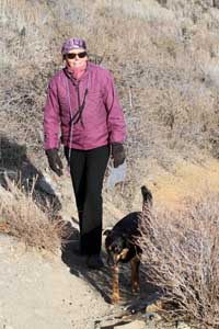 Hiker Ann Fuller enjoys a jaunt on Carbonate Mountain west of Hailey on Wednesday. Hailey and Bellevue have seen more recent snowfall than Ketchum, but it soon melted as a result of clear skies and sunshine, leaving trails like this one high and dry. Photo by David N. Seelig


