

About CommentsComments with content that seeks to incite or inflame may be removed. Comments that are in ALL CAPS may be removed. Comments that are off-topic or that include profanity or personal attacks, libelous or other inappropriate material may be removed from the site. Entries that are unsigned or contain signatures by someone other than the actual author may be removed. We will take steps to block users who violate any of our posting standards, terms of use or any other policies governing this site. Use of this system denotes full acceptance of these conditions. Please review the full rules governing commentaries and discussions. You are fully responsible for the content that you post. The comments below are from the readers of mtexpress.com and in no way represent the views of Express Publishing, Inc. You may flag individual comments. You may also report an inappropriate or offensive comment by clicking here.
Flagging Comments: Flagging a comment tells a site administrator that a comment is inappropriate. You can find the flag option by pointing the mouse over the comment and clicking the 'Flag' link. Flagging a comment is only counted once per person, and you won't need to do it multiple times. Proper Flagging Guidelines: Every site has a different commenting policy - be sure to review the policy for this site before flagging comments. In general these types of comments should be flagged:
|
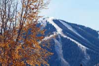 A fresh dusting of snow covers the upper reaches of Bald Mountain on Wednesday. The Wood River Valley is set to see another year of La Niña weather, but weather officials say other factors play into the ultimate amount of snowfall. Photo by David N. Seelig
|
Local Weather |
|||
|
|
|||
 |
|||
 |
|||
 |
|||
 |
|||
 |
|||
 |
|||
 |
|||
 |
|||
 |
|||
 |
|||
 |
|||
 |
|||
 |
|||
 |
|||
 |
|||
 |
|||
 |
|||
 |
|||
 |
|||
 |
|||
 |
|||
 |
|||
 |
|||
 |
|||
 |
|||
 |
|||
 |
|||
 |
|||

|
|||

|
|||
 |
|||
 |
|||
 |
|||
 |
|||
 |

|
Copyright ©
2024
Express Publishing Inc. Terms of Use Privacy Policy The Idaho Mountain Express is distributed free to residents and guests throughout the Sun Valley, Idaho resort area community. Subscribers to the Idaho Mountain Express will read these stories and others in this week's issue. |