Natural and triggered avalanches were rampant this week as Tuesday's storms overloaded an already unstable snowpack, sending county crews scrambling to clear a 35-foot-tall pile of snow and debris from Warm Springs Road.
Chris Lundy, director of the Sawtooth National Forest Avalanche Center in Sun Valley, said the Warm Springs avalanche was one of several natural slides. The avalanche occurred late Tuesday night, blocking both lanes of Warm Springs Road 10 miles west of Ketchum near Frenchman's Bend.
"It's pretty dramatic," Lundy said of the avalanche.
County Director of Operations Char Nelson said county crews worked from 11:30 p.m. on Tuesday until 3 a.m. Thursday, when one lane was finally cleared and traffic could pass.
Crews continued to work through the day Thursday to finish clearing 100 feet of blocked roadway.
One other slope on the south side of Warm Springs slid, but Lundy said it wasn't a large avalanche and it stopped short of the road.
Blase Reardon, avalanche forecaster for the center, reported that one avalanche off of Minebender Ridge—in the East Fork drainage south of Ketchum—ran all the way to the river before stopping. Reardon also reported avalanches in Lake Creek just north of Ketchum and one in the Mistletoe area of the Bald Mountain sidecountry, on skier's right off lower Broadway.
"This is the biggest storm we've had since February," Lundy said. "It was the proverbial straw that broke the camel's back."
The long dry spell that lasted from January to mid-February allowed the top layer of snow to facet, or crystallize, forming a weak layer of sugary snow unable to support a significant amount of fresh snow.
"Once we started getting snow again, immediately we started getting avalanche activity," Lundy said.
Avalanche conditions were intensified both by the amount of snow as well as the relatively warm temperatures, which deposited rain on lower elevations.
Travis Wyatt, a meteorologist for the National Weather Service in Pocatello, said the storm wasn't a large one, but the rain made it a "big event."
< << <
"If you didn't have such a weak layer already, it could have absorbed [the rain] better," he said.
Lundy said the Warm Springs avalanche was so severe because a weak layer released a slab of fresh snow, which picked up "wet, gloppy snow" and debris as it traveled down the slope. The wetter snow is more likely to slide, Lundy said, likening it to slush.
"If you put a 7-11 Slurpee on a steep slope, it doesn't like to stay there," he said.
Wyatt said the snowpack is so saturated because March has been much wetter than normal, due in part to the tropical weather system La Niña. The system generally brings above-average precipitation in the central Rockies, and Wyatt said March's precipitation has been 150 percent of average so far.
Wyatt said that though some snow is expected Saturday, both that and future storm systems are expected to begin as Tuesday's did, with rain that turns to snow at higher elevations.
"We're going to continue to get these rain events," he said.
Lundy said that though the avalanche warning that had been issued Wednesday morning has expired, avalanche danger is still at a high level and not expected to decrease over the weekend.
"We just recommend no one goes out in the south and central valley," he said.
He suggested that terrain in the north valley may be a little safer, but the deeper snowpack may cause more problems.
"The Catch-22 up there is that if you do trigger an avalanche, it's going to be pretty big," he said.
He said the persistent weak layer causing many of the avalanches is not likely to fade any time soon.
"It's probably something we're going to live with for the rest of the winter," he said.
Katherine Wutz: kwutz@mtexpress.com


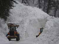 County road and bridge crews clear away more than 35 feet of debris from Warm Springs Road near Frenchmans Bend on Wednesday morning. The Sawtooth National Forest Avalanche Center reported that numerous avalanches occurred throughout the area Wednesday and Thursday, mostly as a result of heavy snows and rain that overloaded a weak layer of faceted snow. Photo courtesy of Chris Lundy.


