The entire Wood River Valley population depends on the same underground aquifer—stretching from north of Ketchum to Picabo where it fans out—but the aquifer is losing water faster than it can be replenished.
James Bartolino, groundwater specialist for the Idaho Division of the U.S. Geological Survey, came to that conclusion in 2009 after studying the amount of groundwater flowing into and out of the aquifer in a 10-year span. He found that groundwater storage is replenished in wet years.
"However, over the long term, more water is removed from storage than is replaced," he said.
Bartolino was able to make such an overall conclusion in his report, but he didn't have the statistics to state exactly what is to blame for the draining and to what extent.
"It is uncertain whether these declining water levels are caused by pumping that has accompanied increased development or are a response to several years of drought conditions," Bartolino wrote in his report.
The uncertainty came about because Bartolino's research wasn't as complete as he wanted. Even though the valley's more than two dozen tributary basins and Big Wood River are the aquifer's greatest supplier, only a single streamflow gauge existed in the drainage, on the Big Wood River in Hailey, at the time of Bartolino's report. For that reason, Bartolino had to implement industry formulas to calculate creek streamflows based on tributary basin areas, which total 560 square miles.
"We just don't know much about what's going on up there," he said.
<
Bartolino and the USGS will soon be able to tabulate several of these exact streamflow rates as it and other government agencies install gauges in the Big Wood River and its main tributaries, such as Trail Creek, where a gauge will be installed near the Second Avenue bridge in Ketchum. Bartolino said that would be Trail Creek's first gauge since the 1920s, a gap that's not uncommon in the valley. Bartolino said not one Wood River Valley tributary was being measured until two weeks ago when a gauge was installed in the East Fork of the Big Wood River. He said the Idaho Department of Water Resources also plans to install a gauge in lower Warm Springs Creek.
"We'll be able to pin these numbers down with much more confidence," he said.
Bartolino said stream levels are such a great indicator because a reduction in groundwater causes stream levels to correspondingly fall. The reverse is also true—if less water flows down the Big Wood River and its tributaries because of human consumption along the way or drought, the aquifer won't see as much replenishment. And the Big Wood River's tributary streams contribute an estimated 63 percent of the aquifer's annual inflow.
"The volume of recharge from tributary canyons ... is more than double the estimated recharge for the next largest recharge source, the Big Wood River," Bartolino said.
However, the Big Wood River isn't closely watched, either.
Bartolino said a gauge hasn't been in place north of Ketchum since 1973. The difference in measurements between that and the Hailey gauge could then be used to see how much water is lost between the two towns, which is important for determining the rate of human consumption. The USGS is in the process of requesting permission from the U.S. Forest Service to install a gauge north of Ketchum.
"Rapid population growth since the 1970s has caused concern about the long-term sustainability of the groundwater resources," Bartolino said.
However, most water consumption by people comes from directly pumping water out of the aquifer, not taking it from streams that would otherwise, in part, reach the aquifer. The USGS estimates that 44 percent of the water drawn from the aquifer is by people. The rest goes into streams.
Bartolino said he couldn't state the rate of human pumping with much confidence in his 2009 report. He said a "large degree of uncertainty" surrounded the number of wells and the amount of water pumped in the valley.
But one thing's for sure: The amount of water pumped by humans has increased in recent decades. Blaine County experienced a 40 percent population growth from 1990 to 2000, jumping from 13,000 residents to more than 20,000, according to the U.S. Census Bureau. The population increased by 11 percent in the next five years.
Trevon Milliard: tmilliard@mtexpress.com


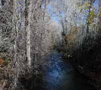 The U.S. Geological Survey is installing a gauge in Trail Creek, above, to measure how much water it carries. Express photo by Roland Lane


