Three storm cycles that began last week have resulted in a 10 percent jump in the water equivalent of the snowpack in the Big Wood Basin and increased an already significant avalanche risk that has been persistent for much of the season.
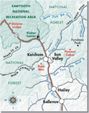
Starting Jan. 18 and continuing through Jan. 22, consistent precipitation dropped about 30 inches of new snow on Bald Mountain, 24 inches in Ketchum and 16 inches on Galena Summit.
According to statistics from the Natural Resources Conservation Service, the storms increased the regional snowpack to 72 percent of average, compared to just over 60 percent at the beginning of the month.
Chris Lundy, avalanche forecaster for the Sawtooth National Forest Avalanche Center, said snowfall in early December followed by a dry spell formed an extremely weak, faceted layer, leading to a highly unstable snowpack.
"It's an unusual year for avalanches," he said. "A lot of experts are seeing things they haven't seen before. The weak layer from December is worse than normal and snow loading has led to deep-slab instability with 2 or 3 feet of snow on top of that weak layer."
Lundy said the deep load on top of a weak layer means there's an increased chance of large slab avalanches.
"Any avalanche you trigger is going to be huge and will probably kill you, so the consequences are pretty high right now," he said.
A quick look on the Sawtooth National Forest Avalanche Center's Web site (www.avalanche.org), shows just how unsafe the backcountry has become, with recent pictures of avalanches from around the Wood River Valley, including one that spans much of Titus Basin, near Galena Summit.
"I've never seen anything like this in 30 years," said Janet Kellam, director of the avalanche center, about the enormous slide. "It's an exceptionally bad year and will remain that way in the backcountry. There are areas near the threshold just waiting for something to break the balance."
Lundy said intermittent snowfall is forecast for the next two weeks, but not enough to lessen the avalanche danger.
"To stabilize the weak layer, it needs compression, but it's not quite there yet," he said. "It will probably get worse before it gets better. It's an unfortunate state of affairs right now."
Jon Duval: jduval@mtexpress.com


