Thanks to cool weather that lasted late into spring, the pond in Hulen Meadows enjoyed high water that was quickly brought in and circulated back to the Big Wood River. But standing by the popular recreational area north of Ketchum in August presents a vastly different scene.
Only two small channels feed fresh water into the pond, which, for the most part, is so still that the small harvest of cottonwood seeds floating in the middle now gives it a swampy appearance.
That's hardly an attractive attribute for the beginner kayaker looking for a place to practice rolling, one of the many uses for the pond over the years.
With a bit of help, the Wood River Land Trust is hoping to rectify this problem.
In fact, in an effort to move away from the connotation of stagnancy implied by the word "pond," Scott Boettger, executive director of the land trust, has started referring to it as the Hulen Meadows Site.
"It's a perfectly made land trust project," Boettger said, standing on the gravel bar at the water's edge on Monday. "It's about restoration and conservation for the public good."
To implement the desired changes, however, the proposed project goes well beyond Hulen Meadows.
Last week, the Ketchum City Council gave interim City Administrator Jim Jaquet the green light to pursue an application for a Recreation and Public Purposes Project, in which the city would acquire two parcels of land from the Bureau of Land Management.
If successful, the city would get a patent or low-cost, long-term lease on a 217-acre parcel extending from Sun Peak Day Use Area to the southern edge of Lake Creek, including the Hulen Meadows site. As part of the same application, the city would also acquire a 164-acre parcel west of Atkinson Park, at the confluence of Warm Springs Creek and the Big Wood River.
Jaquet previously stated at a meeting in April that a patent would be preferable, as it would not cost the city any money and would not have an expiration date as a lease would.
Adding to the complexity of the application is a land exchange with the Blue Canyon Corp., which owns property on the east side of state Highway 75, just south of the entrance to Hulen Meadows.
The city has authorized an expenditure of up to $15,000 for the application, a cost that would go toward a required environmental site assessment, biological evaluation and a cultural resource survey.
If the application is approved, the city will likely construct a water well in the Sun Peak Day Use Area. Ketchum Utilities Superintendent Steve Hansen said the well would fulfill the city's water needs. He said current demand would not be met if the city's largest well were rendered inoperable in an emergency.
Hansen estimated a $900,000 cost for the new well, which would use city water rights to pump groundwater from the Big Wood Aquifer.
However, the land trust could face a significant expense as well, as the non-profit organization has yet to acquire water rights for the site. Boettger estimated that the cost could fall in the area of $500,000. That doesn't include approximately $150,000 needed to push the existing gravel bar to the east, the solution currently envisioned by the land trust.
Since the pond was created in the early 1990s as part of a project to straighten out the nearby highway, it has since been filled with cobblestones and gravel, thanks in part to flooding in 2006 and to the lack of any clear responsibility to maintain it.
This confusion was highlighted during last summer's Castle Rock Fire, during which the BLM did an emergency dredging of the gravel bar so helicopters could fill their buckets.
Currently, the long rocky strip that separates the river from the pond has two thin channels cut into it, the creation of which is illegal, but has been overlooked as they are the only reason any water is moving into the pond at this time of the year.
With the gravel bar pushed to the east, the river would create a natural oxbow, as Boettger put it, and keep fresh water flowing through the site.
In fact, Boettger said pictures from 1943 show that that used to be the river's path.
According to Project Coordinator Kathryn Goldman, pushing the gravel bar from its current location to the eastern bank would create an area conducive to cottonwood and willow regeneration.
In addition to moving the gravel bar, Goldman said the plan would include more plantings throughout the site to restore it to its natural state.
While the land trust awaits approval from Blue Canyon to move ahead with the application, Boettger said he thinks the merits and benefits of the project should garner plenty of support from the community.
"From fishing to kayaking to dogs, the possibilities here are really endless." Boettger said. "No one wants to see it become a West Nile breeding ground."


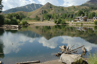 Wood River Land Trust hopes that a deal with Ketchum, the U.S. Bureau of Land Management and a private property owner will lead to the restoration and maintenance of the Hulen Meadows recreation site. That would include relocation of the gravel bar, which currently impedes the flow of fresh water from the Big Wood River into the pond.
Photo by Willy Cook
Wood River Land Trust hopes that a deal with Ketchum, the U.S. Bureau of Land Management and a private property owner will lead to the restoration and maintenance of the Hulen Meadows recreation site. That would include relocation of the gravel bar, which currently impedes the flow of fresh water from the Big Wood River into the pond.
Photo by Willy Cook


