For the U.S. Forest Service and northern Wood River Valley emergency response personnel, a rainy forecast could mean a lot more than just an unfortunate break in the blue skies and warm weather.
Once again, residents and recreationists in the areas affected by last summer's Castle Rock Fire are being warned about the greatly increased possibility of flash floods and mudslides.
"Without vegetation to intercept rainfall, the burned mountainsides have a higher potential for surface erosion and runoff," states a report entitled "Castle Rock Fire Burned Area Emergency Response."
While the Forest Service is conducting erosion and debris flow mitigation on federal lands, Ketchum Fire Department Senior Lt. Tory Canfield said in an interview Monday that the risk will remain for the next three to six years.
A hydrology and soil assessment by the Forest Service calculated that if a significant rain event were to take place, large watersheds, such as the confluence of the Big Wood River and Warm Springs Creek, would experience exponentially greater streamflow.
For example, according to the report, an intense rainfall of 0.8 inches per hour, which happens approximately every 25 years, could lead to the Warm Springs-Big Wood confluence near Ketchum running at 14,485 cubic feet per second. By contrast, before the fire, this type of 25-year rain event would only cause that watershed to rise to 1,076 cubic feet per second.
Canfield said that this 13-fold increase in water flow is indicative of the inherent danger in a number of areas.
In addition to high water in existing rivers, a number of drainages are particular susceptible to debris flow and mudslides. Canfield said that such slides would be extremely hazardous for anyone residing or passing nearby, as well as for downstream residents, as slides can dam up rivers and streams then suddenly give way, creating a flash flood.
Of particular concern for increased flooding are "micro-watershed" drainages, including Huffman Drive Draw; Limekiln; Hot Springs Gulch; above Upper Summer Recreation Cabin; and Lower Board Ranch north drainage.
In addition, homes adjacent to and only slightly elevated above Warm Springs stream, Greenhorn stream, and the Big Wood River between Warm Springs and three miles south of Greenhorn could be in danger during high rainfall.
"We don't have the ability to warn people in the same way we do during hazardous avalanche conditions," Canfield said. "People hiking or biking on trails such as Red Warrior or Adams Gulch need to know what the weather is doing."
As for homeowners in affected areas, Canfield highly recommended creating an evacuation plan and contacting their insurance providers about flood coverage.
"We don't want to panic people, but extreme caution must be used in danger areas during periods of heavy rain," she said.
The city has also instituted a reverse 911 system, called Swift911, which will automatically call specific people or areas in the event of an emergency or for sharing important information. Blaine County Emergency Communications and other departments will use this system to notify citizens by phone to convey vital information. These messages may include information on floods, fires, water emergencies, road closures, missing persons, evacuation orders and weather emergencies.
Blaine County residents interested in this service can get on the system through the Ketchum Web site, www.ketchumidaho.org, and by following the link to "Flood Information." Alternatively, people can call 788-5555, ext. 1016.
The Castle Rock Fire burned nearly 50,000 acres near Ketchum in August and September 2007.


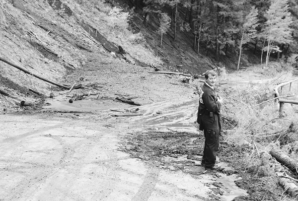 Ketchum Fire Chief Mike Elle stands next to a mudslide in Warm Springs Canyon last fall. Due to the erosion and reduction in vegetation resulting from the Castle Rock Fire last summer, there has been a significant increase in the chance of mudslides and flash floods during periods of heavy rainfall. Photo by David N. Seelig


