Unless new winter storms begin to add to the region's steadily decreasing snowpacks soon, portions of Idaho could face another summer of below-average streamflows and reservoir levels, officials with the Natural Resources Conservation Service warn.
Earlier this month, NRCS officials released updated information regarding the status of the state's overall water supply.
With heavy snowfall throughout the winter, it may appear that there is plenty of water stored in mountain snowpacks for the year, an NRCS news release states. However, conditions in March and April may be key to how much snowmelt actually ends up in Idaho reservoirs and streams this summer.
For now, snowpacks in the 19 Idaho river basins measured by the NRCS continue to look good, with percentages ranging from a high of 116 percent of average in north-central Idaho's Clearwater Basin, to a low of 91 percent of normal in southeast Idaho's Willow, Blackfoot and Portneuf basins.
Based on online data provided by the NRCS, snowpack in the Big Wood Basin, which includes the Wood River Valley as well as the Camas Creek drainage in the Fairfield area, was at 96 percent of average on Thursday.
The figure is calculated by averaging the snow-water content of nine Snotel sites in the Big Wood Basin.
Short for snowpack telemetry, Snotel sites relay a vast array of weather data from remote mountain sites to Idaho's NRCS headquarters in Boise. Snotel evolved from a NRCS congressional mandate in the mid-1930s to measure Western snowpacks to forecast water supply. Today, there are 83 Snotel sites throughout Idaho's mountains.
The current figure for the Big Wood Basin compares to a snowpack percentage of 110 percent of average in the basin just a month ago.
The state's official water season runs from April through September. Many of Idaho's snowpacks typically hit their peak sometime in March. However, last March was an example of what state hydrologists hope will not happen this year. Last year on March 1, NRCS streamflow predictions for the Big Wood River were calling for 78 percent of average streamflow runoff between April 1 through July 1. But because March precipitation in Idaho's central mountains ended up being only 40 percent of average, state hydrologists by April had downgraded that projection to just 53 percent of average runoff for the Big Wood.
"If March is dry like last year, Idaho's snowpacks would peak at only 80 to 100 percent of average in early April," said NRCS water supply specialist Ron Abramovich.
According to the March 1 water supply outlook, snowpacks measured at individual Snotel sites throughout the state are 95 to 130 percent of average across Idaho, and lower-elevation snowpacks are up to 200 percent of average in the northern part of the state.
Abramovich said that while current snowpack numbers are encouraging, it's important to remember that snowfall alone doesn't determine the year's water supply. He said spring and summer streamflows are dependent upon many factors, such as spring and fall precipitation, soil moisture, groundwater and spring levels, geology, spring air temperatures and other factors.
"The wild card in this year's water supply picture is how the above-normal low-elevation snowpack will melt," Abramovich said. "A gradual melt will help prime the hydrologic system and give us a fairly steady flow of water over time. Rapid snowmelt could contain the potential for excessive runoff in unregulated basins."
The NRCS water supply outlook report for Idaho also includes local data on snowpacks, precipitation and reservoir storage. According to the report, February precipitation ranged from only 65 percent of average in the Big and Little Wood river basins to about 110 percent of average in the Clearwater and Bear River basins.
The NRCS projections indicate that summer streamflow forecasts range from 68 percent of average for the Bear River in southeast Idaho to 120 percent in the Clearwater basin.
"With current reservoir storage at average or less across the state, this means that average or better precipitation is needed to maintain snowpacks and keep water supply forecasts from decreasing during March," Abramovich said.


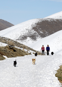 A pair of hikers walk their dogs along snow-free south-facing hillsides in Quigley Canyon east of Hailey on Wednesday. Below-average snowfall in February led to a decline in many of Idaho?s snowpacks, a development state hydrologists say could cause below average runoff this summer if more snowfall doesn?t arrive. Photo by David N. Seelig


