Snowpack percentages in the mountains surrounding the Wood River Valley have been creeping steadily upward over the past few days as a series of Pacific storms has finally overrun the region.
According to online data provided by the U.S. Natural Resources Conservation Service, the snowpack in the Big Wood Basin, which includes the Wood River Valley as well as the Camas Creek drainage in the Fairfield area, was at 89 percent of average on Thursday morning.
The figure is calculated by averaging the snow-water content of nine Snotel sites in the Big Wood Basin.
Short for snowpack telemetry, Snotel sites relay a vast array of weather data from remote mountain sites to Idaho's NRCS headquarters in Boise. Snotel evolved from a NRCS congressional mandate in the mid-1930s to measure Western snowpack in order to forecast water supply. Today, there are 83 Snotel sites throughout Idaho's mountains.
Considered individually, the local Snotel sites reveal a positive trend in snowfall totals that should warm the hearts of area snow devotees.
At the Vienna Mine Snotel site south of Smiley Creek Lodge, the snowpack was recorded at 38.5 inches at 5 a.m. on Monday, Dec. 17. Yesterday at 5 a.m., the snowpack at the site was listed at 51.4 inches, for a combined increase of about 13 inches in 72 hours.
Most other Snotel sites in the Big Wood Basin have shown similar increases in snowpack levels this week.
Arriving as the storms did this week just ahead of the Christmas holiday, local skiers and snowboarders could not have asked for better timing.
However, the thumping Mother Nature has inflicted on the Wood River Valley and surrounding mountains since last weekend has added to the avalanche danger.
In his daily avalanche advisory on Thursday, Matt Lutz, avalanche forecaster with the Sawtooth National Avalanche Center in Ketchum, estimated the danger in local mountains to be moderate. However, Lutz said isolated areas of considerable avalanche danger do exist on steep terrain and exposed ridges due to wind-deposited snow and increasing temperatures.
"The snow totals over the last five days within the heart of our forecast area are between 10 to 16 inches, with some areas of the northern Sawtooths receiving up to 30 inches," Lutz said.
For Thursday, Lutz advised backcountry travelers to expect changing conditions in the local forecast area because of an expected additional six inches of snow in the mountains, moderate westerly ridge-top winds and relatively warm temperatures.
He said small storms during the past five days have deposited 12 to 16 inches of snow at higher elevations in central and northern areas of the valley.
"All this new snow has fallen on a weak old-snow surface," he said.
Lutz said that while the new snow totals are starting to get more impressive, the snowpack has had time to adjust to the new load. He said he doesn't expect widespread instability within the new snow except on steep terrain and on high-elevation ridges with wind-deposited snow.
Lutz said backcountry travelers should be aware that forecasts are calling for temperatures near freezing.
"If the snow turns to rain, the avalanche danger will rise rapidly," he said.
For the most up-to-date and complete avalanche advisory from the Sawtooth National Forest Avalanche Center, log on to www.avalanche.org, or call the center's avalanche hotline at 622-8027.
Based on forecasts from the National Weather Service on Thursday, the Wood River Valley and surrounding areas should expect to see a break in the weather and partly sunny skies on Friday. However, NWS forecasters are calling for increasing clouds by tonight. Overnight temperatures are forecast to drop to a frigid 3 degrees Fahrenheit, with temperatures in the mid-20s during the day Saturday.
The National Weather Service forecasts another storm by Saturday evening, with a 50 percent chance of overnight snowfall in Ketchum. For Christmas Day, it is calling for a chance of snow and mostly cloudy skies. Daytime temperatures should be around 23 degrees.


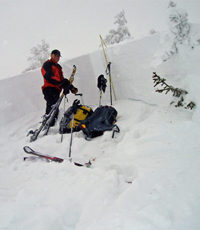 Matt Lutz, an avalanche forecaster for the Sawtooth National Forest Avalanche Center, stands next to the crown of a large slab avalanche in an east-facing bowl on Durrance Peak north of Ketchum in late December 2006. Recent storms have increased the avalanche danger in the mountains surrounding the Wood River Valley, Lutz said in his Thursday, Dec. 20, avalanche advisory.Photo courtesy Sawtooth National Forest Avalanche Center


