A thermal image was beamed to incident commanders at the Castle Rock Fire within minutes from when they were taken on Wednesday night by a "pilotless" aircraft that flew 700 miles from California.
The Ikhana has no pilots on board, but it is always under the control of two pilots with control sticks flying it from a trailer at California's Edwards Air Force Base.
The "near real-time" images taken by NASA's Ikhana, which is a version of the Predator B used in the Middle East, are sent to a satellite and then to the NASA Ames Research Center in Mountain View, Calif. They are then sent within minutes to incident commanders at the Castle Rock Fire and to the federal National Interagency Fire Center in Boise.
Fire commanders sometimes have to wait eight or 10 hours for thermal images from conventional aircraft, said Castle Rock Fire Information Officer David Olson. The Ikhana's images identify hot spots, so we "can use our resources to more efficiently contain the fire."
The Ikhana gets incident commanders "more accurate information, and that allows a fire manager to make a better decision to move suppression forces to key areas," Olson said. "It worked well," and its images were turned into maps used on Thursday, Aug. 30.
Flying at about 23,000 feet, the Ikhana flew seven Idaho fires in a 20-hour mission before returning to California.
The 36-foot-long craft has a wingspan of 66 feet and cruises at between 160 and 180 knots. It costs about $6 million and is crammed with sensors developed by a team lead by Vince Ambrosia of NASA's Western States Fire Mission project. NASA and the United States Forest Service have been working for years to used the Ikhana aircraft for projects like mapping the Castle Rock Fire.


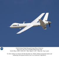 Photo courtesy the NASA Dryden Research Center--
The Ikhana unmanned aircraft flew over the Castle Rock Fire on Wednesday night, providing fire commanders with ?near real-time? images of hot spots. The aircraft flew 700 miles to Idaho from Edwards Air Force Base in California and it?s flown constantly by two ?pilots? with control sticks sitting in a trailer at the base.
Photo courtesy the NASA Dryden Research Center--
The Ikhana unmanned aircraft flew over the Castle Rock Fire on Wednesday night, providing fire commanders with ?near real-time? images of hot spots. The aircraft flew 700 miles to Idaho from Edwards Air Force Base in California and it?s flown constantly by two ?pilots? with control sticks sitting in a trailer at the base.


