In the 15 days since the Castle Rock Fire began burning 10 miles west of Ketchum, the stubborn blaze has challenged firefighters and raced across thousands of acres in nearly every direction imaginable.
It's a wildfire that doesn't seem to know which way it wants to go.
In its first few days, fierce winds sent the blaze in a mostly north-northeasterly direction up Rooks Creek and over several high divides into the Adams Gulch, Eve Gulch and Fox Creek drainages. The advancing flames in those earliest days could easily be seen along the nearby mountainous skylines northwest of Ketchum.
Later last week, the fire seemed to have decided a southeasterly bearing was the more suitable route. At first, just one spot fire showed up in the roadless Red Warrior Creek drainage, just eight miles due west of Ketchum on the south side of the Warm Springs Creek Road.
In time, the spot fire grew into several more that continued to grow and then crested the high ridgeline dividing the Warm Springs Creek drainage on the north from the Greenhorn Gulch drainage on the south.
Last weekend, fierce winds more than doubled the size of the Castle Rock Fire from 18,015 acres to 41,100 acres and sent a wall of flames roaring east down into the main fork of Greenhorn Gulch, where several expensive rural homes barely missed the fiery onslaught. At the same time, fast-moving flames raced north up from Greenhorn Gulch, through the Timber Gulch and the Clear Creek drainages, all the way to within 50 yards of $12 million Seattle Ridge Lodge, just south of the 9,151-foot summit of Bald Mountain.
In recent days, a small smoldering bit of hotness in the basement of the Bassett Creek Gulch became a roaring inferno of smoke, flames and aerial embers that raced east to the top of Bald Mountain's west-facing back side. Several spot fires cropped up in the conflagration's wake on the east and north-facing slopes of the mountain within the boundary of the Sun Valley ski area.
Now, some two weeks in on the major fire suppression effort, crews are fighting a pitched battle on the well-known slopes of Guyer Ridge and west along the north-facing slopes of the Warm Springs Creek drainage to Frenchman's Bend.
So, for all the choking smoke, racing flames and burning embers, it seems the Castle Rock Fire has finally decided it will make it's final stand just several miles away and in the very same Warm Springs Creek drainage where it began. The most up-to-date map of the fire released Thursday, Aug. 30, shows the vast majority of the remaining uncontrolled fire perimeter within the mid- to lower-Warm Springs Creek drainage, only several miles east of the lone lightning-struck tree where it began.
Saying as much Thursday evening at a community meeting at Ernest Hemingway Elementary School in Ketchum was Castle Rock Fire incident commander Jeanne Pincha-Tulley.
"All we have to do is finish this piece, and we can put this to bed," Pincha-Tulley said to an enthusiastic crowd of some 350 to 400 people.
To accomplish that, she said firefighters would be working all night Thursday conducting burnout operations from the Guyer Ridge area west farther up the Warm Springs Creek drainage. So far, crews conducting burn outs in the Guyer Ridge area have had excellent success clearing underbrush and accumulated woody debris, she said.
"That was the whole point of burning out," Pincha-Tulley said. "We actually got a pretty clean underburn there."
After the meeting, fire information officer David Olson said the end goal is to complete the back burns across the north-facing slopes of the Warm Springs Creek area to Frenchman's Bend, which is six miles west of Ketchum and three miles east of the Castle Rock Fire's origin. Olson said five hotshot crews were scheduled to work all night if necessary to complete the burnouts, but could be done as early as 1 or 2 a.m. today, Aug. 31.
"On Friday they'll try to finish that up," he said.
Olson said while the plan was to burn the entire north facing timbered slope from ridgeline to valley floor, not all of the trees in the area should end up burned.
Elsewhere on the Castle Rock Fire, firefighters found significant success digging fire line, conducting burn-out operations and mopping up along its south, west and north flanks, Pincha-Tulley said.
"This is all connected as you can tell," she said as she pointed to the black line on her overhead map indicating controlled fire line.
Her map showed black line along the Fox Creek drainage, from Fox Peak south to Greenhorn Gulch, west to state Highway 75 and north to Seattle Ridge and from Adams Gulch to the mouth of Fox Creek.
Pincha-Tulley said that because fire crews have already completed the majority of the burn-out operations needed to contain the Castle Rock Fire, the Wood River Valley should begin to slowly clear up from the heavy smoke that's been blanketing the area.
Asked the question that's been burning on the minds of many local residents at every one of the five community meetings held so far, Pincha-Tulley sounded a positive note concerning when upper and lower Board Ranch residents may be able to return home.
"Sometime this weekend, hopefully," she said.
Failing that, Pincha-Tulley said she'd probably give the okay for Board Ranch homeowners to return to their houses for a short period of time to see how they've fared.
"I'm sure we can arrange that," she said.
To be considered fully contained, firefighters need to have mopped up all the way around the fire's perimeter at least 300 feet in, fire information officer David Olson said.
Without that, "you run the risk of a new ember coming across that fire line," he said.
For Pincha-Tulley, having firefighters facing the repeated walls of flames that have run up Bald Mountain's back side has worried her the most. While certainly important, she said the ski resort wasn't at the top of her list of worries.
"There's somebody's son and daughter out there," she said.
While Wood River Valley residents should continue to see columns and tendrils of smoke coming from within the burn area for some time, they shouldn't see any more huge columns of smoke indicating the fire is making a major run.
"The odds are pretty slim," she said. "It's going to put up a few columns of smoke here and there."
After Pincha-Tulley departed Thursday evening, Sawtooth National Forest Ketchum District Ranger Kurt Nelson announced another bit of encouraging good news that should cheer the heart of all Wood River Valley hikers, trail runners, mountain bikers and other backcountry trail lovers. Nelson told the crowd he's lifted all Sawtooth National Forest lands on the east side of state Highway 75 in the Boulder and Pioneer mountains from the ongoing public lands closure.
Still under the public lands closure are Sawtooth National Forest lands in Blaine County from Baker Creek south to the Deer Creek drainage on the west side of Highway 75.
At last count Thursday, fire officials estimated the size of the Castle Rock Fire at 46,087 acres and said it was 55 percent contained. That represents just over a 4-percent increase in size from the day, when the blaze was estimated at 44,111 acres.
Firefighting resources assigned to the fire included a total of 1,670 firefighters, 16 helicopters, 10 bulldozers and 104 engines.
To date, no lives or structures have been lost on the wildfire.
Castle Rock Fire: by the numbers
Here are some of the key statistics for Castle Rock Fire through Thursday, Aug. 30:
- Total size: 46,087 acres or 72 square miles.
- Percent contained: 55 percent.
- Number of firefighters: 1,672.
- Date the fire began burning: Thursday, Aug. 16.
- Total cost of fire suppression effort so far: $15 million.
- Structures lost: zero.
For further information, call Ketchum City Hall at 726-7811, or log on to www.blainecounty.org or www.mtexpress.com.
Some evacuation orders lifted
Excellent news seemed to arrive by the hour Thursday, Aug. 30. Here's a rundown of the day's key developments:
- Blaine County officials lifted mandatory evacuation orders for residents living in the lower Warm Springs drainage west of the Warm Springs Bridge to Gates Road, and in the Greenhorn Gulch subdivision beginning at the log arch.
- Officials also downgraded from voluntary evacuation order to advisory status all neighborhoods east of state Highway 75, the Golden Eagle, Timber Gulch, Starweather, Hidden Hollow, River Bend and Alturas Loop subdivisions in the mid-Wood River Valley, the St. Luke's Hospital and neighborhoods in the Adams Gulch, Hulen Meadows and Fox Creek areas north of Ketchum.
Voluntary evacuation means the fire is still close and residents may be required to leave again. It will likely be very smoky for the conceivable future. Voluntary also means residents only, no construction workers or landscapers are allowed in these areas. Advisory warnings are given as a precaution. It means you should be ready to leave in the future, should the fire approach.


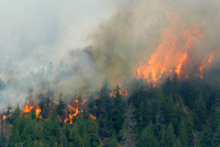 Massive flames from the Castle Rock Fire engulf a forest of conifer trees in the lower Warm Springs Creek drainage west of Ketchum Wednesday.
Photo by David N. Seelig
Massive flames from the Castle Rock Fire engulf a forest of conifer trees in the lower Warm Springs Creek drainage west of Ketchum Wednesday.
Photo by David N. Seelig


