Jack Frost came out swinging last weekend, with many area cities seeing frigid temperatures, but only one—Stanley—seeing record lows.
"The temperatures ... over the last five to seven days are not abnormal," said Gary Wicklund, a meteorologist with the National Weather Service in Pocatello. "This is normal, (but) it might be toward the cold side of normal."
"Stanley is the only one that has broken any records over the last four days," he added.
Thursday, Jan. 11, just before 8 p.m., temperatures in Hailey and Ketchum dropped into the single digits and hovered around zero throughout the night, the first of several such nights. The wind chill factor made the air feel like minus 14 degrees. The worst was yet to come for Stanley, where thermometers hit minus 35 degrees on Friday.
"That was a significant record," Wicklund said. "The very next day it was minus 34."
The previous low in Stanley for Jan. 12 was 26 below zero in 1964. The previous record for Jan. 13 was minus 32, also in 1964. Stanley also saw record cold temperatures Monday, at minus 25, four degrees colder than the previous record set in 1987.
"When you have record events like that, you have to wait a long time for them," Wicklund said. "It takes a long time to break records."
The Arctic air blast came late last week out of central Canada, "where it's very dry and very cold," Wicklund said. "Until we get a good strong system to push it out of the way, it stays."
Newcomers to the Wood River Valley have grown accustomed to mild winters over the past few years, which have been at or above normal, Wicklund said.
"Normal temperatures are in the negatives (for both Stanley and Ketchum)," he said.
Ketchum's record low, recorded at the Ketchum Ranger Station, was minus 38.7, set back in 1950.
Valley residents should see a slight warm-up over the next few days with a very mild weather system moving in, Wicklund said.
Today should be mostly sunny with a slight chance of snow. Highs could reach the mid-20s. Tonight's forecast calls for partly cloudy skies with lows dipping below zero. Thursday's temperatures should warm slightly, with highs of 17 to 25. Temperatures could reach 32 by the weekend.


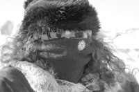 A spectator at The Ski Tour skiercross competition on Dollar Mountain Saturday fights off the frosty temperatures with layers of fleece and fur. Photo by Dana DuGan


