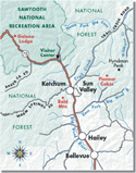
Floodwaters threatened homes in Hailey Tuesday morning as warm weather drove the Big Wood River to flood stage.
The river overflowed its banks in the south part of Hailey, flooding lawns, driveways and crawlspaces in the Della View Subdivision as homeowners worked to pump water out and protect their houses.
Some dozen homes were threatened and part of War Eagle Drive was closed. Water levels subsided later in the day but part of the area remained under water.
"There's two houses that are completely surrounded by water about a block from the river," Hailey Police Lt. Jeff Gunter said Tuesday afternoon.
Gunter said damage was minimal because residents had taken precautions. "There's been a lot of sandbagging. A lot of people were prepared for it."
Farther south floodwaters spilled onto farmlands as the river reached the six-foot flood stage.
The situation is expected to worsen through the week as temperatures near 80 degrees melt the year's unusually large snow pack.
The Big Wood was expected to reach 6.5 feet today and to continue to rise until cresting at nearly seven feet by the end of the week, according to the National Weather Service.
"We're up to our butts in alligators right now," said Chuck Turner, Blaine County Disaster Services coordinator.
"It's all about safety right now -- people should keep their pets and their kids away from the water," he said.
Floating debris threatened to jam up the river and cause flooding in other areas. Crews worked to clean a cottonwood tree from the river near St. Luke's Wood River Medical Center south of Ketchum and elsewhere removed stumps, branches and other detritus from the swollen river.
The NWS in Pocatello issued a flood warning for Blaine County on Monday and predicted "moderate flooding" through the end of the week.
"It all depends on how warm it stays for the rest of the week," said NWS meteorologist Rick Winther. "This is the critical weekend."
Winther said isolated showers are expected by the end of the week. Overcast skies should keep temperatures lower, while light to moderate precipitation shouldn't significantly affect runoff levels.
"By the end of the week we really should eat away a lot of the snow that's in the mountains," he said.
Snow pack in the Big Wood River Basin was about 150 percent of normal this year.
"This is just the beginning," said Turner. "We're going to get more water, so people should just be alert. It's all going to depend on the warm weather and how fast the snow melts.
"Hopefully we won't have any big rain storms," he said. "But you prepare for the worst and hope for the best."


 War Eagle Drive in Hailey was closed Tuesday to all but emergency vehicles because of water across the road from the swollen Big Wood River. Photo by Willy Cook


