Winter and spring clearly have some issues to resolve.
November and early December were highlighted by a series of storms that left a solid base of snow across the Wood River Valley and surrounding hills. By the second week of December a cold snap hit the region, plummeting overnight lows below zero for 14 of 17 nights.
Then, spring-like, comparatively balmy temperatures and rain transformed Ketchum's streets from virtual ice rinks into slushy streams.
All this, and winter hadn't even officially begun.
When it did on Dec. 21, it seemed more like the first day of spring, dawning warm and wet. Green grass poked through sagging, waterlogged patches of snow in Hailey. More than a few people strolled through downtown Ketchum in shorts. And across most of the valley's Nordic trails, water skis seemed more practical than skate skis.
But if there has been any consolation to the rain, it's that it fell as snow up high.
On Dec. 23, for the first time in days, a soggy layer of fog and clouds lifted to reveal beaming peaks caked in a top-heavy layer of white. In three days, the top of Baldy picked up 20-inches of heavy, wet snow.
At least in the mountains, winter arrived on schedule, and with a bit of a punch.
By Dec. 26, the snowpack in the Big Wood River Basin was 107 percent of average—reached by averaging the snow-water content of nine Snotel sites in the basin.
Short for snowpack telemetry, Snotel sites relay a vast array of weather data from remote mountain sites to Idaho's National Resources Conservation Service headquarters in Boise. Snotel evolved from a NRCS congressional mandate in the mid-1930s to measure Western snowpack in order to forecast water supply. Today, there are 78 Snotel sites scattered across the mountains of Idaho.
Ron Abramovich, a hydrologist with the NRCS and head of Idaho's Snotel program, said the rain-snow line, which has ranged between 6,500 and 8,000 feet for the past week, is abnormally high for this time of year and the snow that has fallen is wet. But given the ongoing drought, which is entering its seventh year, any moisture is better than none.
"We'll take it any way we can get it," Abramovich said.
Climate experts are warning that over the next several decades winters in the West will become increasingly warm and wet.
"It is very likely that more winter precipitation will fall as rain instead of snow, periods of snowpack accumulation will be shorter, and snowpacks will be smaller," stated a September 2005 report from the Rocky Mountain Climate Organization, based in Colorado.
But Vernon Preston, a meteorologist with the National Weather Service in Pocatello, said the string of warm, wet storms is not as unusual as it may seem, and it can't be labeled a symptom of climate change and global warming.
"A little event like this is so minute in the realm of any type of warming or cooling," Preston said. "This is basically a fluctuation of the weather. It's quite common, it's something that comes and goes.
"A lot of it just depends on weather patterns."
Preston said the recent storms have had roots in the warm waters of the Central Pacific, which produces a flow commonly referred to as the Pineapple Express. A similar flow developed over southern Colorado last winter, delivering heavy valley rain and more than 100 inches of snow to the mountains north of Durango.
The wet flow has blessed the Big Wood Basin. The Snotel site on Galena Summit, 30 miles north of Ketchum, reported a hefty snowpack that was 121 percent of average on Monday.
Only Oakley Basin, located southeast of Twin Falls, is off to a wetter start, with a snowpack at 109 percent of average. Meanwhile, the snowpack in Idaho's panhandle was at a state-low 57 percent of average on Monday.
The Big Wood Basin hasn't seen above-normal snowfall since the winter of 1998-1999, when the seasonal snowpack was 116 percent of average, according to Abramovich.
Since then, a drought has plagued the region and winter snows have generally been meager. In 2001, the snowpack was just 47 percent of average. Last winter's low snowfall (67 percent of average) was countered by massive spring rains—precipitation in May was a staggering 257 percent of average.
The last truly snow-laden winter was in 1996-1997, when snowfall was 240 percent of average, according to Abramovich. Dating back to 1917, only 1965 and 1983 were bigger, and not by much.
Preston said the seasonal outlook is calling for equal chances of above- and below-normal precipitation through the winter with slightly above-normal temperatures in the spring.
"A lot of times when that happens we end up with more of a westerly or southwesterly flow," he said, adding that such a scenario often translates into increased precipitation. "We're crossing our fingers on that."
Furthermore, the drought assessment from the National Weather Service is calling for "some improvement" across much of Idaho through March.
Abramovich, who keeps an eye on weather trends and cycles, said the southern half of Idaho is due for a big winter. For years, ski bums have sworn by the seven-year cycle, which refers to seven years of relatively dry weather followed by seven years of wet. Although many call it a myth; Abramovich admitted it deserves some credence.
Looking at annual stream flows on the Big Wood River over the past 25 years, distinct cycles can be seen. Between 1980 and 1986, most years were wet with some big winters. The late 1980s and early 1990s were pretty dry. Wet conditions returned in the mid-1990s with several years of high stream flows. Beginning in late 1999, a dry period re-emerged. This past summer, stream flows on the Big Wood River below Magic Reservoir were above average for the first time in seven years.
"If you look back at the past 14 years, 1992 was a low point, 1997 and 1998 were (high), and again in 2004 we were back at a low point," Abramovich said. "Hopefully we have bottomed out. But I'm not going to speculate.
"As soon as I tell you one thing, the other will happen."
------------------------------------------------------------------
Snowpack
Big Wood Basin snowpack percentages as of Monday, Dec. 26
Snotel Site Percent of Average
· Camas Creek Divide 105
· Chocolate Gulch 118
· Dollarhide Summit 94
· Galena (town site) 114
· Galena Summit 121
· Hyndman 106
· Lost-Wood Divide 116
· Soldier Ranger Station 90
· Vienna Mine 105
Basin Wide 107


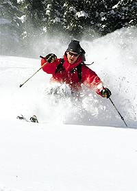 Scott Douglas enjoys dry backcountry powder in November. Express photo by Chris Pilaro


