 |
For the week of May 19, 1999 thru May 25, 1999 |
|
For the week of May 19, 1999 thru May 25, 1999 |
Snowpack hangs onBy KEVIN WISER
According to Gale Roberts, director of the Blaine Soil Conservation District, snowpack percentages have actually risen in the last three weeks. "Normally we would be losing an inch of water every day," Roberts said. Roberts said snowpack is melting-off at lower elevations, but increasing above 9,000 ft because of unseasonably cold temperatures and recent snows. "The water is coming out as slow as it can," Roberts said. "We still have 22 inches of water at the higher elevations." As for the potential for flooding, Roberts said it all depends on the weather. However, Roberts cautioned that the longer the snowpack stays at higher elevations the greater the chance for flooding. Bruce Lium of American Water Resources said that 22 inches of water is historically what we would have in the mountains during the first part of April. "That curve has not gone down this year," Lium said. "We’re still at peak levels due to cool temperatures and little run-off." Lium said predicting the possibility of flooding is like a roll of the dice. "If we get out of this cold spell we could see a potential for high water," Lium said. "If we stay in this cold pattern we could see a more gradual run-off and less potential for flooding." Lium referred to 1999 as a year to be cautious. "River-front property owners should be aware of the potential for high water flows." Blaine County Commission chair MaryAnn Mix said the county has made preparations in the event that flooding should occur. Mix said the county has purchased additional sandbags which are available to the public at a cost of 30 cents per bag. Mix said that people who chose to build along the river prior to implementation of the flood plain overlay district in 1991 stand a chance of losing land along the river from erosion during high water events. Currently, the flood plain overlay requires a 75-foot setback for development along the river. Mix said John Cline, director of the Bureau of Disaster Services, indicated he was not overly concerned with the potential for flooding on the Big Wood River, but that he was very concerned about northern Idaho.
|
| |
| Copyright © 1999 Express Publishing Inc. All Rights reserved. Reproduction in whole or in part in any form or medium without express written permission of Express Publishing Inc. is prohibited. |
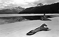 Due to cool temperatures and slow run-off, snowpack in the Big and
Little Wood River drainages is at 150 percent of average while water content at Chocolate
Gulch stands at 261 percent of normal.
Due to cool temperatures and slow run-off, snowpack in the Big and
Little Wood River drainages is at 150 percent of average while water content at Chocolate
Gulch stands at 261 percent of normal.